Build the VAB Evidence Binder That Wins Your Ag Appeal
How to Build the Evidence Binder That Wins at the VAB Hearing
The DR-486 petition took fifteen minutes. The filing fee was $15. The form preserved the right to a hearing. Now comes the work that determines whether the hearing produces a reversal or a confirmation of the denial.
The evidence binder is the single document that matters most at the Value Adjustment Board hearing. The magistrate will have read the Property Appraiser’s file before you walk in. Your binder is the organized, sourced, exhibit-tabbed response that tells the magistrate exactly why the denial was wrong — not in generalities but in specific statutory terms, with specific evidence behind each claim. The magistrate is not persuaded by emotion. The magistrate is persuaded by the direct line between the evidence and the requirements of Florida Statute 193.461.
This post walks the binder exhibit by exhibit — what goes in each tab, how to organize the satellite imagery timeline, how to format the comparable-properties table, and how to write the opening summary the magistrate reads first. Every recommendation below comes from the binder we built for our own case. Black Hammock Farm, Petition #2025-1003. Twenty-one pages. The methodology is transferable to any agricultural classification denial in any Florida county.
This is Post 6 of The Denied G1 Series— a twelve-post field guide built from inside the fight.
Quick Answer
What goes in the evidence binder for an agricultural classification VAB hearing?
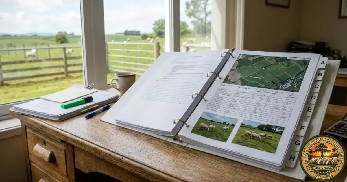
Eight tabs. Tab A: the filed petition, the denial letter, and all correspondence. Tab B: the Property Appraiser’s internal file on your parcel. Tab C: date-stamped photographs of the property showing agricultural use across multiple seasons. Tab D: satellite imagery organized chronologically from the oldest available to the most recent, annotated with what each image shows. Tab E: business records — Schedule F, livestock sales receipts, feed and veterinary invoices, lease agreements, Premises ID, insurance. Tab F: a comparable-properties table identifying nearby parcels with agricultural classification and their assessed values. Tab G: printed statutory and case law authority connecting your evidence to Florida Statute 193.461. Tab H: a one-to-two-page written summary of the case. Our binder ran to 21 pages. The magistrate is not impressed by volume. The magistrate is impressed by organization, accuracy, and the direct connection between every exhibit and a specific requirement of the statute. Build the binder with the September 2025 evidence exchange in mind — everything in the binder is what you deliver to the Property Appraiser at least 15 days before the hearing.
The Governing Principle — Every Exhibit Answers the Statute
Before building a single page, understand what the magistrate is looking for. The magistrate’s job is to determine whether the Property Appraiser correctly applied Florida Statute 193.461 to your parcel. That statute, walked line by line in Post 4 of this series, requires three things: (1) the land is used primarily for bona fide agricultural purposes, (2) the agricultural use is conducted in good faith commercial character, and (3) the use is assessed against seven statutory factors including length of time, continuity, size of operation, and the effort to care for the land.
Every page in the binder should answer one or more of those requirements. A photograph that shows livestock grazing answers “primarily agricultural use.” A satellite image spanning ten years answers “length of time.” A Schedule F answers “good faith commercial character.” A comparable-properties table showing that identical parcels carry classification answers “consistent application of the standard.” If a page does not connect to the statute, it does not belong in the binder. Discipline is the difference between a 21-page binder that wins and a 60-page binder that loses the magistrate in the first five minutes.
Tab A — Petition and Correspondence
Tab A is the procedural foundation. It establishes the record and shows the magistrate that everything that follows was filed on time, in order, and in response to a specific denial.
Tab B — The Property Appraiser’s File
Under Florida Statute 194.032, the Property Appraiser must provide you with a copy of your property record card and their evidence. In our case, the SCPA submitted a 24-page presentation to the VAB magistrate. We obtained every page of it, printed it, and put it in Tab B.
This tab exists for one reason: so you can rebut the appraiser’s arguments point by point. Read the appraiser’s file closely. Mark every factual claim, every photograph, every assessment. In our case, the appraiser’s own satellite imagery showed 90 percent pasture usability post-hurricane in November 2023 and “fully grazeable” status in May 2021 — evidence that contradicted the denial reasoning on the face of the appraiser’s own submission. Your opponent’s evidence can become your strongest exhibit if you read it carefully enough.
Request the Property Appraiser’s internal file in writing within 72 hours of receiving the denial letter. Do not wait for the evidence exchange deadline. The earlier you have their file, the more time you have to organize your response around their specific arguments.
Tab C — Photographic Evidence
Tab C is where the magistrate sees the farm. Ground-level, date-stamped photographs of the property showing agricultural use across multiple seasons and multiple years. Not a single harvest-day snapshot. Not a hero image. A chronological timeline that documents the continuous, working character of the operation.
Our binder included eight photographs spanning 2020 through 2025. Each photograph was printed on a full page with four pieces of information below the image: the date the photograph was taken, the location on the property (e.g., “Pasture A, looking east”), what the photograph shows (e.g., “Ewes and lambs grazing on spring regrowth”), and the statutory factor it addresses (e.g., “Length of time in agricultural use — F.S. 193.461(3)(b)”).
The table above is representative. Your photographs will come from your property and your operation. The structure is the same: chronological order, caption, statutory connection. If the appraiser’s denial letter says the land is “not sustainable,” make sure at least two photographs show livestock thriving during the season the appraiser claims sustainability fails. If the denial says “not commercial,” include photographs showing infrastructure — fencing, feed storage, water systems, shelters. Match the photographs to the denial. The magistrate reads the denial first. The photographs answer it.
Tab D — Satellite Imagery Timeline
Tab D is where the length-of-time argument is won. Ground-level photographs show what the farm looks like. Satellite imagery shows what the farm has looked like, uninterrupted, for a decade or more. The source is free: Google Earth’s historical imagery slider, which stores satellite captures dating back to the early 2000s in most Florida counties. The Seminole County Property Appraiser’s Base Map Gallery also publishes current satellite views with parcel overlays.
Our binder included eleven satellite images spanning February 2014 through September 2025 — an eleven-year record of continuous pasture use. Each image was printed at approximately half-page size with three annotations below it: the capture date, a one-sentence description of what the image shows (e.g., “Full grazeable status across Pasture A; 100 percent green coverage”), and a usability rating expressed as a percentage (e.g., “90% usable — confirmed by infrared analysis”).
The table above shows four of our eleven images. Include as many captures as you have access to. The point is the pattern: year after year, the land is in agricultural use. The longer the timeline, the harder it is for the appraiser to argue that the use is temporary or speculative. An eleven-year record of continuous pasture answers the “length of time” factor definitively.
One additional note: check the appraiser’s own satellite imagery. In our case, the SCPA’s file contained satellite images that showed the pasture in usable condition — images the appraiser included but interpreted as evidence of seasonal flooding rather than seasonal productivity. We placed the appraiser’s images side by side with ours in the binder, with captions noting that the appraiser’s own evidence supported classification. The magistrate sees both interpretations. The images do not lie.
Tab E — Business Records
Tab E answers the “good faith commercial agricultural use” requirement. The statute does not require profitability. It does not require a minimum revenue threshold. It requires good faith — meaning the operation is conducted in a businesslike manner with the intent to generate income from agricultural products. The business records demonstrate that intent.
Include what you have. Not every farm will have all of these. The principle is the same: the more documents that show the operation is conducted in a businesslike manner, the harder it is for the appraiser to characterize the use as “incidental” or “speculative.” One Schedule F and three years of feed invoices are more persuasive than a verbal claim that “we farm the land.”
Tab F — Comparable Properties
Tab F is, in our experience, the exhibit that changes the hearing. This is the table that shows the magistrate that parcels within a half-mile radius of the denied property — parcels with identical soils, identical hydrology, identical or lesser agricultural activity — carry the classification you were denied. The argument is not that you deserve special treatment. The argument is that you deserve the same treatment.
We identified 33 parcels within a half-mile radius of 1579 Walsh Street carrying G1 agricultural classification: 26 classified as G1 Grazing Land, 5 as AG Homestead HX Cutout, and 2 as G1 Ornamental. The comparable parcels carry assessed values in the $180 to $209 range. Our parcel, reclassified residential, was assessed at $470,587. That is approximately a 1,007-fold differential on physically equivalent land. The methodology for building this table — how to search the SCPA Record Search, how to filter by classification code, how to cross-reference the NWI wetlands overlay — is the subject of Post 10 in this series.
The table in your binder should include at minimum: the parcel ID, the property address, the acreage, the classification code, the assessed value, and one column noting any observable difference between that parcel and yours. If no meaningful difference exists — which, in most cases it will not — the column reads: “No observable difference in use, soils, or hydrology.” Thirty-three rows of that phrase tell the magistrate everything.
Of the 33 G1 parcels we identified, only 2 showed actual cleared grazing land on satellite imagery. The remaining parcels displayed dense tree canopy and heavy forestation. They carried G1 Grazing Land classification. Our parcel, with active livestock and cleared pasture, was denied. The comparison writes itself.
Tab G — Legal Authority
Tab G is short and precise. It is a one-page summary of the statutory and case law authority supporting your classification, with the full text of each cited source printed behind the summary page for the magistrate’s reference. The legal framework was walked in detail in Post 4 of this series. The minimum set of authorities for an agricultural classification binder includes:
Print the summary page and place it at the front of Tab G. Behind it, include printed copies of each cited statute and case. The magistrate may or may not look at the full text, but having it immediately available signals that your legal citations are real and verifiable. It also prevents the appraiser from mischaracterizing what the statute says — you can point to the printed text and read the relevant language aloud.
Tab H — The Written Summary
Tab H is the document the magistrate reads first. It is one to two pages long. It is the narrative that connects every exhibit in the binder to the statutory standard and tells the magistrate, plainly, why the denial was wrong.
The summary should follow a simple structure. Opening paragraph: who you are, what the parcel is, what the operation is, how long it has been in continuous use, and what the appraiser denied. Middle paragraphs: the evidence that answers the denial, organized by statutory factor — primary use, bona fide agricultural purpose, good faith commercial character, length of time, comparable treatment. Closing paragraph: the specific relief you are requesting — reversal of the denial, classification as agricultural, and assessment at agricultural use value.
Write the summary in the documented-pattern voice. Calm. Factual. Sourced. No invective. No accusations against individuals. No emotional appeals. The magistrate has a statutory framework to apply. Your summary makes the application easy by organizing the evidence so that each statutory requirement is clearly met. A well-written summary tells the magistrate: “Here is the standard. Here is the evidence. The standard is met.”
The summary references exhibits by tab letter: “Satellite imagery spanning 2014 through 2025 (Tab D) documents eleven consecutive years of pasture use.” The magistrate can flip to the tab and verify the claim. Every assertion in the summary should be verifiable within the binder. If it is not in the binder, it is not in the summary.
Preparing for the Evidence Exchange
As covered in Post 5 of this series, the September 2025 evidence exchange requirement mandates that both parties provide their evidence to each other at least 15 calendar days before the hearing. The binder is your evidence. The day you deliver a copy of the binder to the Property Appraiser is the day you comply with the evidence exchange requirement.
Build two identical copies of the binder: one for the magistrate and one for the evidence exchange. Deliver the exchange copy to the appraiser’s office by hand with a dated receipt, or by certified mail with return receipt. Keep the receipt in Tab A of your hearing copy. The receipt proves compliance. If the appraiser objects to any of your evidence at the hearing on the grounds that it was not exchanged, the receipt ends the objection.
What the Series Looks at Next
The next post in this series, publishing June 18, takes apart the wetlands argument — the single most common reason used to deny agricultural classification in east Seminole County. What the appraiser says about wetlands. What the statute actually says. What Florida Administrative Code 12D-5.003(4) specifically provides about seasonally flooded pasture. And what our own professional wetlands delineation found about the actual source of the standing water the appraiser photographs.
Frequently Asked Questions
How many pages should the evidence binder be?
There is no minimum or maximum. Ours was 21 pages. The right length is determined by how many exhibits are needed to answer each point in the denial letter and meet each statutory factor. A 12-page binder with clear, organized, statute-connected evidence is stronger than a 50-page binder that buries the magistrate in irrelevant detail. Every page should answer a specific statutory requirement. If a page does not, remove it.
Do I need professional photographs or can I use phone photos?
Phone photos are fine. What matters is the date stamp and what the photograph shows, not the camera that took it. Use your phone’s native camera, which embeds date and location in the metadata. Print the photographs clearly, include the date visibly in the caption, and describe what the image shows. Professional photography is unnecessary.
What if I do not have satellite imagery going back more than a few years?
Google Earth’s historical imagery slider is available for free and typically provides captures dating back to the early 2000s in most Florida counties. Open Google Earth, navigate to your parcel, click the clock icon, and slide backward through the available dates. Save a screenshot of each relevant capture with the date visible. If historical imagery is limited for your area, use what is available and supplement with any historical photographs, agricultural records, or tax returns that document earlier agricultural use.
Should I include a written rebuttal of every point in the appraiser’s file?
Yes — within the written summary (Tab H) or as a separate rebuttal document if the appraiser’s file is lengthy. In our case, the SCPA submitted a 24-page presentation. We produced a separate point-by-point rebuttal that addressed every factual claim, identified where the appraiser’s own evidence contradicted the denial reasoning, and corrected factual errors. If the appraiser claims your revenue is $3,000 and your Schedule F shows $17,000 to $44,000, that discrepancy belongs in the rebuttal. The magistrate reads both. The discrepancy speaks for itself.
Can I add exhibits to the binder after the evidence exchange?
Under the September 2025 evidence exchange requirement, both parties must provide their evidence at least 15 days before the hearing. Evidence not exchanged on this timeline may be subject to objection by the Property Appraiser at the hearing. Build the binder completely before the exchange deadline. If you receive the appraiser’s evidence through the exchange and need to respond to a new argument, you may be able to present rebuttal material at the hearing — but the core of your case should be in the exchanged binder. Do not plan to add material after the deadline. Plan to be ready early.
CTA
Sources & References
Every assertion in this piece is sourced to official Florida statutory text, administrative code, DOR procedural guidelines, or the documented experience of Black Hammock Farm’s own VAB case. The links below open the original sources directly.
Florida statutes, regulations, and constitutional authority
Florida Statute § 193.461— Agricultural lands; classification and assessment. The controlling statute. Seven factors, bona fide use, primary use, dwelling provision.
Florida Statute § 194.032— Hearing procedures; exchange of evidence. The mandatory evidence exchange requirement effective September 2025.
F.A.C. § 12D-5.003— Dwellings on Agriculturally Classified Land. Dwelling provision and the wetland/hydric-soils provision at subsection (4).
Florida Statute § 194.011— Assessment notice; objections to assessments. VAB petition procedure and filing requirements.
Uniform Policies and Procedures Manual for Value Adjustment Boards— Florida Department of Revenue, August 2025.
Case law
Straughn v. Tuck, 354 So.2d 368 (Fla. 1977). Classification depends on actual land use, not residential improvements.
Gianolo v. Markham, 555 So.2d 438 (Fla. 5th DCA 1990). “Primarily” means the most significant activity on the land.
Dept. of Revenue v. Amrep Corp., 358 So.2d 1343 (Fla. 1978). Classification depends on land use, not improvement value.
Citrus County v. Halls River Dev., 520 So.2d 682 (Fla. 5th DCA 1988). Classification applies regardless of owner’s primary occupation or residence.
Seminole County property records and GIS tools
Seminole County Property Appraiser — main site. Record Search, Downloads, Base Map Gallery, GIS data.
U.S. Fish and Wildlife Service — National Wetlands Inventory. Federal wetlands mapping and classification data.
Google Earth. Historical satellite imagery slider for multi-year agricultural use documentation.
Florida DOR forms
Form DR-486— Petition to the Value Adjustment Board. The filing form walked in Post 5 of this series.
