Wetlands Argument Dismantled: Seasonal Flooding & Ag Class
The Wetlands Argument Dismantled — What the Law Actually Says About Seasonal Flooding and Agricultural Classification
If your agricultural classification was denied in east Seminole County, there is a reasonable chance the denial letter mentions wetlands. Standing water. Seasonal flooding. Hydric soils. Language suggesting that some portion of your land is too wet to qualify for agricultural use.
This is the single most common argument used to deny agricultural classification in areas where the land is flat, the water table is high, and the summers are wet — which describes most of Central Florida. The argument sounds reasonable on its face. It is not supported by the statute, the administrative code, the Florida Department of Revenue guidelines, or the actual condition of the land the Property Appraiser is photographing.
This post dismantles the wetlands argument in three layers. Layer One: what the regulatory text actually says about seasonal flooding and pasture land. Layer Two: what happens when the wetland is not natural but artificially created by county infrastructure. Layer Three: what the Property Appraiser’s own evidence shows when you read it against the denial reasoning.
This is Post 7 of The Denied G1 Series— a twelve-post field guide built from inside the fight.
Quick Answer
Does seasonal flooding disqualify land from agricultural classification in Florida?
No. Florida Administrative Code 12D-5.003 governs dwellings on agriculturally classified land. The Florida Department of Revenue’s Real Property Guidelines Section 8.0 rates pasture land at 80 to 100 percent productivity even with hydric soils. Florida Statute 373.406(2)— the Henderson Act — exempts agricultural activities from state wetland regulation when the activities are consistent with normal and customary farming practices. And F.S. 373.406(14) provides that no permit may be required for activities affecting wetlands created solely by unauthorized flooding or interference with natural surface water flow caused by an unaffiliated adjoining landowner — which includes county drainage infrastructure. Seasonal flooding is not a disqualifier. Florida law recognizes it as a normal condition of agricultural pasture in this state. The Property Appraiser photographs standing water in September. The statute says that is pasture.
Layer One — What the Regulatory Text Actually Says
The wetlands argument rests on the implicit assumption that land with seasonal standing water or hydric soils is disqualified from agricultural classification. The Florida regulatory framework says the opposite. Six independent legal authorities address the relationship between wetlands and agricultural land use, and every one of them supports classification.
Read these authorities together. The administrative code says pasture land includes areas that are seasonally flooded. The DOR guidelines rate that pasture at 80 to 100 percent productive. The Henderson Act exempts agricultural activities on classified land from wetland regulation. The FDACS manual gives operational guidelines for grazing livestock in and around wetlands. The constitution directs preservation of the land as it is. There is no authority in the Florida regulatory framework that says seasonal flooding disqualifies land from agricultural classification. The argument that it does is an invention.
Layer Two — When the Wetland Is Not Natural
Even if seasonal flooding could disqualify land from agricultural classification — and the regulatory framework says it cannot — the argument collapses entirely when the wetland condition is not natural but artificially created by external infrastructure.
In our case, we did not rely on legal argument alone. We hired a licensed environmental consultant to investigate the source of the standing water the Property Appraiser photographs. Gary Exner, a licensed environmental consultant, conducted a professional wetlands delineation on May 16, 2016. His finding: the wetland condition on the property is artificially saturated by overland flow from the county’s stormwater drainage ditch running along the north and east sides of the property. The county failed to maintain the drainage ditch for sufficient flow movement. The standing water the appraiser photographs is not a natural wetland. It is the result of county infrastructure that is not being maintained.
The county creates the standing water through unmaintained drainage infrastructure. The Property Appraiser photographs the standing water. The Property Appraiser denies classification based on the standing water the county created. The landowner pays the tax consequence of the county’s failure to maintain its own ditch.
This is where Florida Statute 373.406(14) becomes critical. The statute provides that no permit may be required for activities affecting wetlands created solely by the unauthorized flooding or interference with the natural flow of surface water caused by an unaffiliated adjoining landowner. The county’s drainage ditch is exactly that: infrastructure owned and operated by an entity other than the landowner, whose failure to maintain adequate flow movement creates the saturated condition the appraiser then uses against the landowner.
If you suspect that standing water on your property is caused by external drainage infrastructure — a county ditch, a neighbor’s grading, a road drainage system — a professional wetlands delineation is the exhibit that proves it. The delineation identifies the source of the saturation, distinguishes between natural hydrology and artificial conditions, and gives you a documented, expert finding that the appraiser’s photographs do not show what the appraiser claims they show.
Layer Three — The Property Appraiser’s Own Evidence
The strongest argument against the wetlands denial is often inside the Property Appraiser’s own file. In our case, the Seminole County Property Appraiser submitted a 24-page presentation to the VAB magistrate. Pages 12 through 20 consisted primarily of aerial and satellite photographs the appraiser selected to show standing water and seasonal flooding. The appraiser interpreted these images as evidence that the land was “not usable or sustainable” for agricultural purposes.
We read every page. Four images contradicted the denial reasoning on the face of the appraiser’s own submission.
The appraiser labeled one image “Fully Grazeable.” The appraiser included climate data confirming six dry months per year. The appraiser submitted a post-hurricane image showing 90 percent recovery. Then the appraiser concluded that the land was not usable or sustainable for agriculture. The denial reasoning contradicts the appraiser’s own evidence. You do not need to invent arguments against the wetlands claim. You need to read the appraiser’s file.
Seasonal Usability — What the Calendar Actually Looks Like
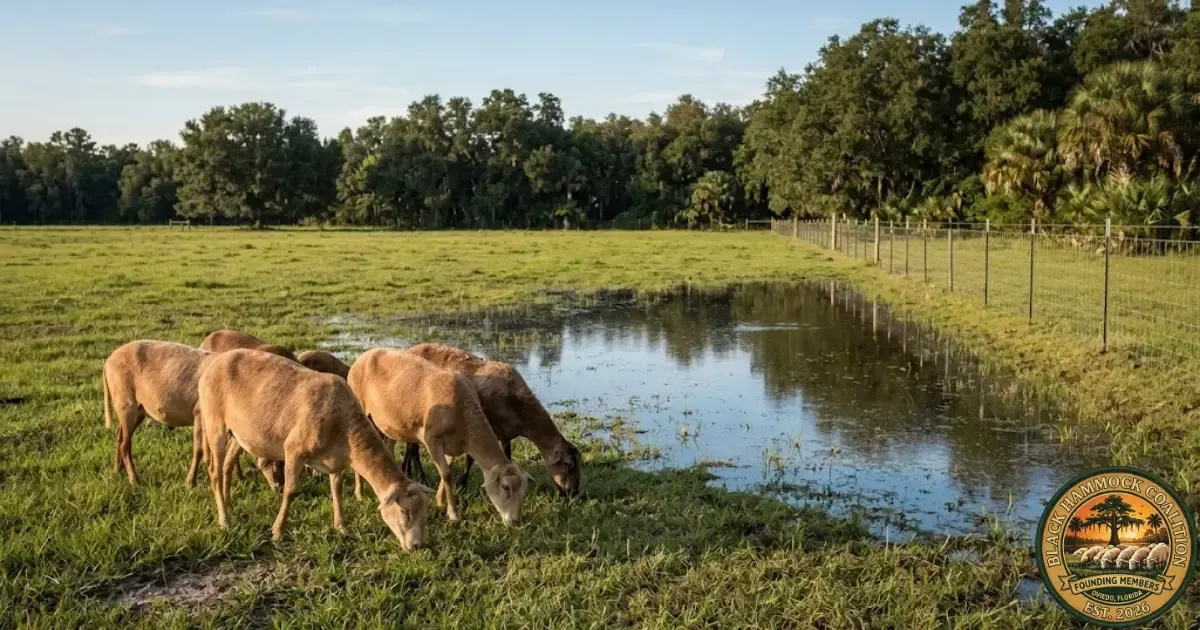
The wetlands argument treats seasonal flooding as though it renders the land permanently unusable. The operational reality on our farm — documented across five years of photographs and eleven years of satellite imagery — shows four distinct seasonal phases, all of which support grazing at varying intensities.
Twelve months of the year, every month, the land supports grazing at 80 percent or above. During the peak dry season, it supports grazing at 95 to 100 percent. The Florida DOR guidelines rate pasture with hydric soils at 80 to 100 percent productivity. Our operational data confirms that range exactly. The land does not stop being agricultural in September. The water table rises, the livestock move to higher ground within the same parcel, the forage keeps growing, and the operation continues. That is what seasonal pasture looks like in Florida.
The NWI Overlay — G1 Parcels on Federally Mapped Wetlands
If the wetlands argument were applied consistently, it would disqualify most of the G1-classified parcels in east Seminole County. The National Wetlands Inventory— the federal wetlands mapping system maintained by the U.S. Fish and Wildlife Service — shows what the county already knows: the land in the Black Hammock subdivision is flat, the water table is high, and freshwater emergent wetlands and freshwater forested shrub wetlands are mapped across a significant portion of the area.
We overlaid the NWI data with the Seminole County Property Appraiser’s plat map showing all G1-classified parcels within a half-mile radius. Multiple G1 Grazing parcels sit directly on mapped wetlands per the National Wetlands Inventory. These parcels have hydric soils. They have seasonal standing water. They have the same characteristics the appraiser cited to deny our parcel. They carry G1 agricultural classification.
The comparable-properties methodology behind this analysis — how to run the NWI overlay, how to cross-reference the SCPA plat map, how to identify the specific parcels — is the subject of Post 10 in this series. The point for this post is simpler: if wetlands disqualified land from agricultural classification, the county would need to revoke classification on dozens of parcels within a half-mile of ours. It has not done so. The standard is being applied selectively.
How to Respond to the Wetlands Argument in Your Binder
If your denial letter cites wetlands, seasonal flooding, standing water, or hydric soils, the response belongs in three tabs of the evidence binder from Post 6.
Tab D — Satellite Imagery Timeline. Organize your satellite images chronologically and annotate usability percentages for each season. Show the magistrate that the land supports grazing across all twelve months. Include the appraiser’s own satellite images side by side with yours if they contradict the denial reasoning.
Tab F — Comparable Properties. dentify G1-classified parcels within your radius that sit on NWI-mapped wetlands. If they carry classification with the same soils and the same hydrology, the appraiser cannot logically deny yours on wetland grounds without revoking theirs.
Tab G — Legal Authority. Print the regulatory framework table from this post. Include the full text of F.A.C. 12D-5.003, the DOR Real Property Guidelines Section 8.0, and F.S. 373.406(2) and (14). The magistrate should be able to read the regulatory language and see that seasonal flooding is not a statutory basis for denial. If you have a professional wetlands delineation, it goes in this tab as well.
What the Series Looks at Next
The next post in this series, publishing June 21, takes apart the primary use argument — the claim that because a residence sits on the property, the land cannot be “primarily” agricultural. What the Property Appraiser says about the dwelling. What Florida Statute 193.461(3)(b) actually requires. What F.A.C. 12D-5.003 says about dwellings on agricultural land. And what three Florida appellate courts have ruled about the relationship between home value, agricultural revenue, and the meaning of the word “primarily.”
Frequently Asked Questions
Does Florida law say that wetlands cannot receive agricultural classification?
No. Florida Administrative Code 12D-5.003 recognizes that pasture land includes areas that are seasonally flooded or have hydric soils. The Florida DOR Real Property Guidelines rate pasture with hydric soils at 80 to 100 percent productivity. Florida Statute 373.406(2) exempts agricultural activities on classified land from state wetland regulation. There is no statutory provision in Florida that disqualifies land from agricultural classification solely because of seasonal wetness or the presence of hydric soils.
What if the standing water on my property is caused by county drainage infrastructure?
Florida Statute 373.406(14) specifically addresses wetlands created by unauthorized flooding or interference with natural surface water flow caused by an unaffiliated adjoining landowner. If the saturation on your property is caused by county drainage ditches, road runoff, or neighboring infrastructure, the state does not treat the resulting wetland condition as a natural wetland for regulatory purposes. A professional wetlands delineation can document the artificial source of the saturation and distinguish it from natural hydrology.
How much does a professional wetlands delineation cost?
Costs vary by property size, complexity, and the consultant’s rates. For a property in the 5-to-20-acre range in Central Florida, a basic wetlands delineation typically runs between $1,500 and $5,000. The delineation produces a documented, expert finding about the source and nature of the wetland condition on your property. In a case where the Property Appraiser’s primary denial argument is wetlands, the delineation can be the single highest-value exhibit in the evidence binder.
Do other G1 parcels in Seminole County sit on wetlands?
Yes. When we overlaid the National Wetlands Inventory data with the SCPA plat map, multiple G1 Grazing parcels within a half-mile radius of our property sit directly on federally mapped freshwater emergent wetlands and freshwater forested shrub wetlands. These parcels carry G1 agricultural classification. The same wetland characteristics the appraiser cited to deny our parcel are present on parcels the appraiser approved. The methodology for running this analysis is covered in Post 10 of this series.
What is the Kissimmee River Valley reference and why does it matter?
The Kissimmee River Valley in south-central Florida is home to some of the state’s largest cattle operations. These ranches operate with 30 to 40 percent seasonal wetland coverage across their acreage and carry agricultural classification. If seasonal wetlands disqualified land from agricultural use, the Kissimmee River Valley cattle industry would not exist. Florida’s agricultural classification framework is designed for a state where seasonal flooding is a normal condition of the land. That is the entire point of the DOR guidelines rating pasture at 80 to 100 percent productivity with hydric soils.
Sources & References
Every assertion in this piece is sourced to official Florida regulatory text, statutory language, professional environmental consultation, or the documented experience of Black Hammock Farm’s own VAB case. The links below open the original sources directly.
Florida statutes, regulations, and constitutional authority
Florida Statute § 193.461— Agricultural lands; classification and assessment. The controlling statute for agricultural classification.
F.A.C. § 12D-5.003— Dwellings on Agriculturally Classified Land. Pasture land includes areas seasonally flooded or with hydric soils.
Florida Statute § 373.406— Exemptions (Henderson Wetlands Protection Act). Subsection (2): agricultural activities exempted from wetland regulation. Subsection (14): artificially created wetlands provision.
Florida Department of Revenue, Real Property Guidelines, Section 8.0 — Pasture land productivity ratings with hydric soils (80–100%).
Florida Constitution, Article X, Section 18 — Constitutional mandate for agricultural classification to encourage preservation of agricultural lands.
FDACS and UF/IFAS guidance
FDACS BMP Manual for Cow/Calf Operations— Water Quality Best Management Practices including wetland grazing guidelines.
UF/IFAS Extension — Handbook of Florida Water Regulation: Activities in Wetlands— Agricultural exemptions from wetland regulation under federal and state law.
Federal wetlands mapping
U.S. Fish and Wildlife Service — National Wetlands Inventory— Federal wetlands classification and mapping data.
Professional environmental consultation
Gary Exner, Licensed Environmental Consultant — Professional wetlands delineation, May 16, 2016. Finding: wetland on property artificially saturated by overland flow from county stormwater drainage ditch along north and east sides of property.
Seminole County property records
Seminole County Property Appraiser— Record Search, Base Map Gallery, GIS plat maps.
Series cross-references
Post 4: Florida Statute 193.461 in Plain English— The full statutory framework walked line by line.
Post 5: The DR-486 Petition Form Field by Field— How to file the VAB appeal.
Post 6: How to Build the Evidence Binder That Wins at the VAB Hearing— The eight-tab binder structure.
