Tax Math Behind Ag Classification Denial: Real Numbers
The Tax Math Behind Every Agricultural Classification Denial — What It Actually Costs the Landowner Every Year the Denial Stands
The first eight posts in this series examined the legal framework — the statute, the administrative code, the case law, the evidence binder, the wetlands defense, the primary use argument. This post is about the numbers. What the denial actually costs. In dollars, from our own case, compared to the properties around us that carry the classification we were denied.
These are not hypothetical figures. Every number in this post is sourced to the Seminole County Property Appraiser’s public records, the county tax roll, or our own documented case materials. You can verify any of them through the SCPA Record Search.
This is Post 9 of The Denied G1 Series— a twelve-post field guide built from inside the fight.
Quick Answer
What does an agricultural classification denial actually cost?
In our case, the denial means paying $5,621.47 in annual property taxes on a parcel assessed at $470,587. The adjacent property — same subdivision, same soil, same water table — carries G1 agricultural classification with an assessed value of $540 and annual taxes of $5.58. That is a 1,007-fold tax differential between two parcels separated by a fence line. Three additional comparable properties within the half-mile radius carry assessed values in the $180 to $209 range. Every year the denial stands, the cost is roughly $5,600 more than what similarly situated landowners pay on physically equivalent land. Over five years, the cumulative overpayment exceeds $28,000.
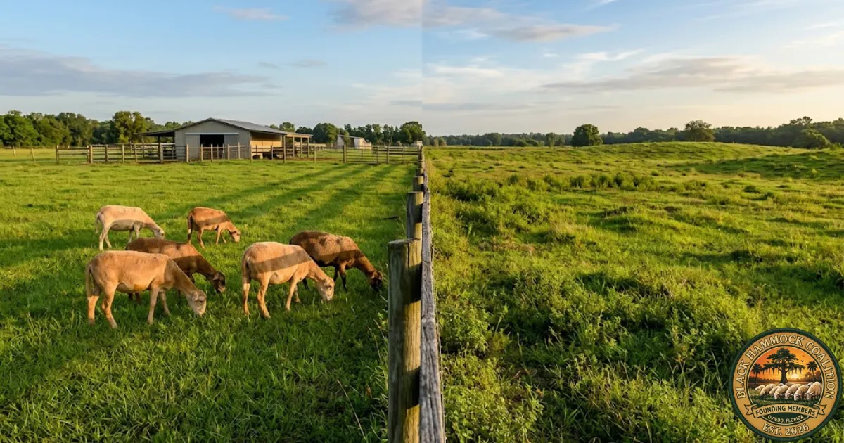
Two Properties, One Fence Line
The single most important comparison in our case is the one that requires the least explanation. Two adjacent parcels. Same subdivision — Florida Groves Company’s First Addition to Black Hammock. Same soil. Same water table. Same hydric conditions. Separated by a fence line. Different classification. Different assessment. Different tax bill.
The property with the documented commercial operation, the infrastructure investment, the Schedule F filings, and the livestock visible on satellite imagery pays 1,007 times more in property taxes than the adjacent property with minimal observable agricultural activity. Both parcels sit on the same water table, in the same subdivision, on the same soil type. The only structural difference: one was approved, one was denied. The classification decision is the entire tax differential.
The Comparable Properties — What the Neighborhood Pays
The adjacent property is not an outlier. Three additional G1-classified parcels within the half-mile radius carry comparable assessed values. These are public records available through the SCPA Record Search.
The parcel with the documented livestock operation, the visible infrastructure, the Schedule F filings, and the professional wetlands delineation is assessed at more than 2,000 times the value of parcels showing heavy forestation and no evidence of active agricultural use on satellite imagery. These comparable parcels carry G1 Grazing Land classification. The methodology for identifying and verifying these comparables is the subject of Post 10 in this series.
The Annual Cost of Denial
The denial is not a one-time event. It is a recurring annual cost. Every year the property remains classified residential instead of agricultural, the assessment stays at market value and the tax bill reflects it. The numbers compound.
*The range reflects the assessed values of comparable G1 parcels in the half-mile radius ($180–$540). Actual taxes on those parcels range from approximately $2 to $56 per year. The table assumes constant assessment and millage rates for illustration; actual amounts vary year to year with county millage adjustments and property value changes.
Over five years, the cumulative overpayment approaches $28,000. Over ten years, it exceeds $56,000. That is money that could have been reinvested in the agricultural operation — fencing, feed, veterinary care, breeding stock, equipment, infrastructure maintenance. Instead, it goes to the tax collector, based on an assessment that treats working pasture as residential land.
Every year the denial stands, the farm subsidizes the county budget at a rate 1,007 times higher than the adjacent property. The cost of the appeal — the filing fee, the evidence binder, the time — is a fraction of what the landowner loses in a single year of overpayment.
How Agricultural Classification Changes the Assessment
When land is classified residential, the Property Appraiser assesses it at market value — what the parcel would sell for on the open market based on comparable sales in the area, improvements, location, and highest-and-best-use analysis. For a 4.653-acre parcel in east Seminole County with a residence, that assessment comes to $470,587.
When land is classified agricultural under F.S. 193.461, the Property Appraiser assesses the agricultural portion at agricultural use value— what the land is worth based on its agricultural productivity, not its development potential. For grazing land in Seminole County, that value is measured in hundreds of dollars, not hundreds of thousands. The residence and curtilage are still assessed separately at just value under F.S. 193.011. But the agricultural acreage — the majority of the parcel — drops from market-rate residential to agricultural use value.
This is why the comparable parcels with G1 classification show assessed values of $180 to $540. That is not an error. That is the agricultural use value of grazing land in this area. The statute was designed to produce exactly this result — to assess agricultural land based on what it produces as farmland, not what it would sell for as a residential lot. The Florida Constitution mandates agricultural classification “in order to encourage the preservation of agricultural lands.” The assessment differential is the mechanism.
The 33-Parcel Pattern
Within a half-mile radius of our property, 33 parcels carry G1 agricultural classification: 26 classified as G1 Grazing Land, 5 as AG Homestead HX Cutout, and 2 as G1 Ornamental. Each of these parcels benefits from the agricultural assessment. Each pays property taxes based on agricultural use value rather than market value.
Of the approximately 10 to 12 parcels classified as G1 Grazing Land that we examined on the SCPA’s satellite imagery, only 2 showed actual cleared grazing land. The remaining 8 to 10 showed heavy forestation, dense tree canopy, and no visible evidence of active grazing or agricultural activity. These parcels carry G1 Grazing classification and the agricultural assessment that goes with it.
Our parcel — with active livestock visible on satellite imagery, $150,000 to $260,000 in infrastructure, documented revenue, and five years of continuous operation — is assessed at $470,587. The forested parcels with no visible agricultural activity are assessed in the hundreds of dollars. The assessment difference between our denied parcel and the average approved comparable is not a matter of degree. It is a difference in kind — a factor of more than 2,000.
The Seminole County Millage Rate
For context, the Seminole County general fund millage rate for the 2025 tax year is 5.3751 mills— $5.3751 per $1,000 of taxable value. This was the first general fund millage increase in 16 years, approved by a 4-to-1 county commission vote in September 2025. The total combined millage (county, school district, and special districts) brings the effective rate higher, which is why a $470,587 assessment produces a $5,621 tax bill after homestead exemptions.
On an agricultural assessment of $180 to $540, the same combined millage produces a tax bill of approximately $2 to $56. The math is simple: the assessment is the multiplier, the millage is the rate, and the product is what the landowner pays. When the assessment drops from $470,587 to $540, the tax bill drops proportionally. That is what classification does. That is what the denial takes away.
How to Calculate Your Own Differential
If your agricultural classification was denied, you can calculate your own tax differential using public records. The process takes about 30 minutes with the Property Appraiser’s online tools.
The differential is the exhibit that changes the hearing. When the magistrate can see a number — not a legal argument, not a regulatory citation, but a dollar figure showing what the landowner pays versus what the neighbors pay on physically equivalent land — the denial has to be justified against that number. In our case, the number is 1,007. The appraiser has not offered a rationale for it.
Why This Matters for the VAB Hearing
The tax math serves two purposes in the hearing. First, it establishes the stakes. The VAB magistrate needs to understand that this is not a technical disagreement about classification codes. It is a $5,600-per-year financial impact on a working farm family, recurring every year, compounding over time. The numbers make the consequence tangible.
Second, and more important, it establishes the equal protection argument. Florida Statute 193.461 requires uniform application of classification standards. If similarly situated properties receive different treatment, the appraiser must explain the differential. A 1,007-fold disparity between adjacent parcels on the same soil in the same subdivision is not a judgment call. It is a number that requires an answer. Our evidence binder asks the question. The appraiser’s file does not contain the answer.
What the Series Looks at Next
The next post in this series, publishing June 28, walks the comparable-properties methodology step by step — how to use the Property Appraiser’s Record Search to identify G1 parcels in your radius, how to cross-reference the NWI wetlands overlay, how to pull satellite imagery, and how to build the comparison table that goes in Tab F of your evidence binder. The 33-parcel analysis from our own case, with the search process documented so you can replicate it for your property.
Frequently Asked Questions
How much can agricultural classification save on property taxes in Florida?
The savings depend on the market value of the property, the agricultural use value assigned by the county, and the local millage rate. In east Seminole County, the difference between a market-value residential assessment and an agricultural use-value assessment for grazing land can be a factor of 800 to 2,600. On our parcel, the denial costs approximately $5,600 per year compared to what similarly classified adjacent properties pay. The annual savings from classification typically range from several hundred dollars on smaller parcels to several thousand on larger ones.
What is the assessed value of agricultural grazing land in Seminole County?
Based on public records from the Seminole County Property Appraiser, G1-classified grazing parcels within a half-mile of our property carry assessed values in the $180 to $540 range. These assessments reflect agricultural use value — what the land is worth based on its productivity as pasture, not its market value as a residential lot. The specific assessment for any parcel depends on soil type, productivity rating, and the county’s agricultural use value schedule.
Can I get a refund for years the classification was wrongly denied?
Generally, a successful VAB appeal applies to the tax year under review — the year for which the petition was filed. Florida law does not provide an automatic mechanism for retroactive refunds of taxes paid in prior years based on a successful classification appeal in a later year. However, if the classification should have been granted in prior years based on the same facts, consult a Florida property tax attorney about whether separate legal remedies may be available. The most effective strategy is to file the VAB petition promptly after denial to minimize the years of overpayment.
What does the 1,007-fold differential mean?
It means that our property is assessed at a value 1,007 times higher than the adjacent property that carries G1 classification. In tax terms, we pay approximately $5,621 per year; the adjacent property pays approximately $5.58. Both properties sit on the same soil, in the same subdivision, with the same water table. The only difference is the classification decision. The 1,007 figure is derived by dividing our annual tax bill ($5,621.47) by the adjacent property’s annual tax bill ($5.58).
Where can I look up comparable property assessments in my county?
Every Florida county Property Appraiser maintains a public Record Search, typically accessible through the appraiser’s website. In Seminole County, the search is available atscpafl.org. You can search by address, parcel ID, or owner name. The record for each parcel shows the classification code, assessed value, taxable value, and tax history. The step-by-step methodology for building a comparable-properties analysis is covered in Post 10 of this series.
Sources & References
Every dollar figure in this piece is sourced to Seminole County Property Appraiser public records, the county tax roll, or Black Hammock Farm’s documented case materials. The links below open the original sources directly.
Seminole County property records and tax data
Seminole County Property Appraiser— Record Search, Base Map Gallery, GIS plat maps. All assessed values, tax amounts, and classification codes cited in this post are available through the SCPA public records search.
SCPA Tax Roll Files— Countywide assessment data, taxable values, and millage information.
Seminole County millage rates
Seminole County FY 2025/26 Millage— General fund millage rate of 5.3751 mills, approved September 23, 2025.
Florida statutes
Florida Statute § 193.461— Agricultural lands; classification and assessment. Subsection (6)(a) governs the assessment methodology for classified agricultural land.
Florida Statute § 193.011— Factors to consider in deriving just valuation.
Federal wetlands mapping
U.S. Fish and Wildlife Service — National Wetlands Inventory— Federal wetlands classification data used in the NWI overlay analysis.
Series cross-references
Post 6: How to Build the Evidence Binder— Tab F (comparable properties) is where the tax differential analysis goes.
Post 7: The Wetlands Argument Dismantled— NWI overlay showing G1 parcels on federally mapped wetlands.
Post 8: The Primary Use Argument Dismantled— Property 045B (homestead with G1 classification) as a comparable.
